
What hardware and software do I use for overland navigation?
In a previous post I told you about how do we prepare the 4x4 routes , and in this post I’m going to talk about the hardware and software we use to navigate on our journeys - what I use to navigate and how and why I use it.
The truth of the matter is that I don’t have a great deal of experience in the sense that I have been using practically the same hardware since the outset. I haven’t used that many alternatives, and so I’m not very experienced in rating them, although it’s also true that I started off by analysing different options, ranging from specific navigation devices for overland/off-road trips – such as the Garmin devices – and other types of non-specific hardware like tablets and mobiles.
My first experience was with a tablet, specifically, an iPad. After talking to several colleagues about the subject and accompanying them in their cars, I decided to try things out with a tablet. Why a tablet? Why an iPad? Simply, because I already had one – I didn’t have to buy anything new, I didn’t need to spend any money.
Initially, I ruled out alternatives offered by Garmin simply because of screen size. Any version of the iPad seemed like a better option to me, as I said, owing to screen size. I thought that Garmin screens were too small and irrespective of the fact that I already had an iPad and the price of the Garmin, this seemed like a major hindrance and so I wasn’t convinced.
And so I decided that the first choice would be the iPad. The next step was to decide what navigation software to use. When talking to friends and overlander companions, I found that most of them used tablets with Twonav to navigate. There is a version for Apple, for iPad, and so I bought the premium version and started using it.
I was using this iPad-Twonav combination for a while, but found once everything had been got ready, with maps and routes loaded on the iPad, the navigation itself turned out to be easy and practical. The problem was until I reached that stage, until I managed to load the maps onto the iPad. It proved to be too much of a time-consuming operation – it took too long. On the other hand, obtaining the maps either by buying them, with the cost involved, or downloading them using Land software, which was very slow, seemed unacceptable to me. And so I started to reconsider my initial decision.
And that’s how, after checking and talking with more people, I learned about the existence of the Oruxmaps programme (I’m providing you with the link to their website). Oruxmaps is a free-of-charge software navigation device that works very well – and I mean, really well. Apart from working with a great variety of map formats, maps can also be created with it and downloaded very easily and, above all, quickly. We can create personalised maps of any area we want, as I said, very easily and very quickly. They can even be created and downloaded from the phone.
Any problem with Oruxmaps? There’s no version for Apple, for the iPad. It requires tablets that work with Android. I was looking for tablet alternatives and ended up going for a Samsung Galaxy Tab. I installed the programme and started using it. Like all programmes, you need a bit of learning time to be able to grasp all its functions, although once you’ve done that, I think it’s the perfect option.
While I was trying out the Oruxmaps app, I was also using the two alternatives for a while, i.e. the iPad with Twonav and Samsung with Orux. I must say that both options seemed very good to me. As I said before, once we have the Twonav and iPad properly configured with the maps and routes, this is also an app that works perfectly – both of them work just fine from my experience
Back then, I got into the habit of carrying two navigation devices at the same time. Following a friend’s advice, I started carrying the most expanded route possible on one device depending on circumstances at any given time, so as to be more up-to-date with the finer details of the terrain and the route itself and, on the other, a more distant, general overview of it, to help anticipate upcoming situations.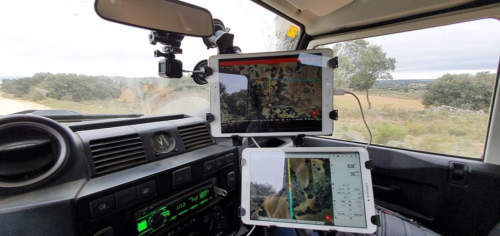
What’s more, carrying two navigation devices at the same time – two tablets – enables me to carry two different types of map – one on each. I always try to carry aerial photographs on one of them and a different map format on the other. Currently I’m using two tablets, although I’ve ruled out the Apple iPad option, because it’s too costly and less compatible, and so I use two Samsung tablets instead. As for the software, I’m still using both the Twonav and Oruxmaps programmes, although with an obvious preference for Orux. And as for the maps, on one tablet I’m using the hybrid Google map, which I download from Orux, and IGN versions on the other, which I also download from Orux.
This, as I say, has been my experience. The fact of the matter is I don’t have that much experience in the matter, as you can see. I think it’s because I’ve found an optimum solution using Oruxmaps and the Samsung tablets that I’m getting very good results, which is why I haven’t felt the need to keep looking into other options.
I don’t know what kind of experiences you’ve had about this, or what other solutions you may have found, and so I encourage you to tell us about them in the comments if you like.